|
(This article appeared in January 1999 AAPG Explorer) By KAREN RAE CHRISTOPHERSON (Click on figures to enlarge)
|
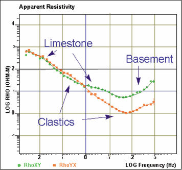
MT Data Throws Curves to ViewersAfter Magnetotelluric (MT) data areacquired, they are run through several processing steps.In part, noise is removed from the data. Examples ofnoise are thunderstorms, power lines, pipelines, and trains. Part of the processing involves comparing the data at one station to another station that was recorded at exactly the same time (remote-referencing). Any non-coherent signal between the two stations is considered noise and discarded from the time series. MT measures changes in the electric and magnetic fields with time. The data are transformed from the time-domain to the frequency domain. At each station, about 40 points in the subsurface are derived, as a measurement of apparent resistivity (and phase) vs. frequency. The lower the frequency, the deeper theinformation. Some sample MT data are displayed in Figure 1, which shows apparent resistivity (in ohm-meters) vs. frequency (in Hertz). The data are plotted on a log-log curve, so "2"means 102 or 100, and 0 means 10 or 1. Why are there two curves?
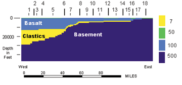
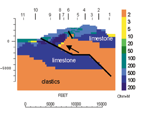
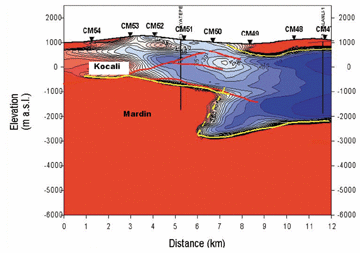
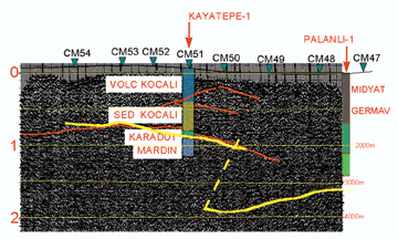
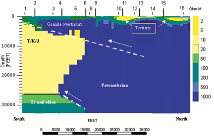
Hence, at every MT station we get two curves. These data are processed so that they align with approximate geologic dip and strike, regardless of the layout in the field. The processing takes several hours per station. InterpretationThe MT method assumes that the earth structure is two-dimensional, i.e. that there is a dip and strike. Therefore, most MT stations are acquired along profiles (2-D) or on a grid (3-D) from which profiles can be extracted. Almost all MT interpretation is done in 2-D, usually dip lines. There are 3-D codes available, but they still require large amounts of computing power and are not normally practical for prospect level exploration problems. The MT interpreter takes the processed data and interprets it to a representation of true resistivity versus depth. This can be doneusing forward or inverse modeling. With forward modeling, the interpreter creates a cross-section, computes the MT response and compares it with the acquired data; for inverse modeling, the interpreter allows the computer to create a cross-section from the acquired data. Both types of modeling result in cross-sections or maps of the subsurface where the resistivity of the subsurface is interpreted to represent certain geologic formations or units (See figures 2 and 3 ) MT interpretation is not easy, and a good interpreter must look at the data (not rely on inversion only) and must integrate geology. There are two commercial MT workstations running on PCs. They allow the interpreter to process, review, edit, interpret, plot and map data. They also allow for the integration of other types of geophysical and geological data (e.g. structure, well logs, surface dips). Often MT interpretation can be done rapidly in the field, allowing for changes or additions to field programs during acquisition. Current Application of MTThere are hundreds of MT systems in use throughout the world for petroleum exploration, most being run by national oil companies (such as China, Japan and India) and a handful of contractors. Since MT works best in areas of seismically high-velocity cover, many of these areas are frontier provinces. In recent years, MT data for petroleum exploration have been acquired in Italy, northern Africa, China, Japan, the western United States, Colombia, Turkey, Greece, Albania, Jordan, Greenland, Pakistan, the Arabian peninsula, Papua New Guinea and the Gulf of Mexico (marine MT). Listed here are a few case histories involving theuse of MT. Columbia Plateau, Washington state.Thousands of MT stations were recorded in the Columbia Plateau during the 1980s in an effort to map the basin beneath the thick cover of flood basalts. In places the basalt thickness exceeds 20,000 feet. Shown in Figure2 is a 2-D MT model cross-section, from west to east, extending from central Washington to near the Idaho border. Station locations are shown across the top of the section. The section shows the Miocene flood basalts (light blue), the Oligocene/Eocene clastics (including volcanoclastics) in yellow, and basement (in dark blue). The section is vertically exaggerated about 5:1. The resistivity of these units (as modeled) is shown on the right scale. The MT model shows the basalts and clastics thinning dramatically from west to east, with the clastic section absent at the far east end. In this area, the basalts were probably deposited directly on basement rocks. Seismic data are almost impossible to acquire because of the thickness of the basalt cover. Several wells were drilled on the Plateau that had good ties to the MT data. Papua New Guinea.The Papuan Fold Belt extends lengthwise trending northwest along the island of New Guinea. Here, Tertiary carbonates have been thrust and folded into structures trapping large quantities of oil and gas. Several large fields have been discovered here in the past decade. The thickness of the carbonates in the fold belt is about 3,000 feet ñ and in places it doubles or triples in thickness due to thrusting. Seismic acquisition is expensive (more than $100K per mile for 2-D data) and the data are usually poor in quality. MT data have been acquired over many structures to map the base of the surface carbonate unit and the thickness of subtrust carbonates (if present). The target reservoirs are Cretaceous sands, sealed by younger shale, and trapped in folds created by the thrusting. Figure 3 shows an MT model through an anticline in the fold belt. Only 11 MT stations were acquired, along a dip profile. The MT data were interpreted and this resulting 2-D model shows the Tertiary Darai limestone (in blue) and the older clastics in orange. The limestones are very resistive compared to the clastics (a contrast of almost 500:1). The primary thrust is shown, emplacing limestone and clastics in the hanging wall, with limestone also present in the footwall. The target is the folded clastics in the hanging wall. There are also possible footwall plays. MT interpretations on some structures in Papua New Guinea have estimated base limestone (pre-drill) to within 2 percent to 7 percent of drilled depth. TurkeyMuch MT data have been acquired in Turkey owing to the outcrop of carbonates, volcanics, and other high-velocity rocks. Figure 4 shows an interpreted MT profile and the corresponding seismic data. The red areas indicate more resistive units, and blues shows the more conductive units. The section is plotted with north on the left. The Kocali (an ophiolitic melange) was thrust over clastics and carbonates. All are Mesozoic in age. The target is the Mardin carbonates. The seismic data are of poor quality. However, the principal reflectors were converted to depth and plotted on the MT section (red lines). The MT data show a more resistive section at depth corresponding to the Mardin. The results show good correlation to well data. Granite Overthrust, southern Wyoming.Figure 5 shows an inversion of 15 MT stations acquired along a north-trending profile in southern Wyoming. Precambrian granites were thrust from north to south. The section is true scale, with no exaggeration. The Precambrian granites are high in resistivity (500 + ohm - m). The subthrust Cretaceous/Jurassic rocks are 10-50 ohm-m. A thin Tertiary section is present on the Precambrian at the surface. A possible secondary thrust fault is seen deeper in the section. Possible normal faults cut the thrust plate. The structure has not been drilled. This survey was done to investigate the subthrust structure before acquiring seismic data. Editor's note: Christopherson has a BS in geology and an MS in geophysics. She has over 22 years experience using MT, working for the U.S. Geological Survey, BP (Sohio) and has been president of Chinook Geoconsulting in Evergreen, Colo., for the past 10 years. Her e-mail is chinookgeo@aol.com. |